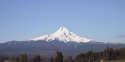
Mount Hood is the highest peak in Oregon and one of the most frequently climbed glaciated mountains in the world.
Its sharp cone dominates the skyline only 45 miles (70 km) east of Portland, and a dozen glaciers keep the peak
permanently snowbound. Two major ski areas are found on the south side, and the lifts at Timberline run year-round
on the Palmer Glacier (snowfield), fed by nearly 500 inches (12 m) of annual snowfall. Hood is skiable directly
from the true summit by several routes, although all of them are quite steep and somewhat exposed. Below the
summit area, the slopes moderate greatly and there are numerous excellent possibilities for safe and uncrevassed
ski runs.
| Route |
Ratings |
Starting
Elevation |
Elevation
Gain |
Roundtrip
Distance |
Notes |
| Quality |
Effort |
Ascent |
Descent |
| Summit Ski Mountaineering Routes:
|
South Side /
Palmer Glacier |
 |

7.5 |
 |
 |
5900 ft
(1800 m) |
5300 ft
(1600 m) |
8 miles
(13 km) |
The standard South Side route follows the Palmer Glacier above the highest lifts, allowing
one to cheat and use the lifts in order to make a quick ascent. The upper portion of the
ski descent from the summit used to be considered quite extreme, but recent ablation of
the glacier has reduced the risk somewhat, although the large bergschrund (crevasse) is
still hazardous in spring. This 45-50 degree pitch drops directly from the highest point
into the steaming and sulfurous remains of Hood's crater, and then moderates in slope
below the crater as it returns to the top of the lifts.
(See my ski trip report from April
1998.) |
Wyeast Face
from Mt Hood Meadows |
 |
8.0 |
|
|
5300 ft
(1600 m) |
5900 ft
(1800 m) |
9 miles
(14 km) |
Route info... |
| Cooper Spur |
 |
7.5 |
 |
 |
5900 ft
(1800 m) |
5300 ft
(1600 m) |
8 miles
(12 km) |
Route info... |
| Sunshine Route |
 |
7.5 |
|
|
5900 ft
(1800 m) |
5300 ft
(1600 m) |
10 miles
(16 km) |
Route info... |
| Other Ski Mountaineering Routes:
|
Circumnavigation
near 8500 ft level |
|

8.5 |
|
|
5900 ft
(1800 m) |
5500 ft
(1700 m) |
12 miles
(20 km) |
Route info... |
| Illumination Saddle |
|

5.0 |
 |
 |
5900 ft
(1800 m) |
3400 ft
(1000 m) |
6 miles
(10 km) |
Route info... |
Zig Zag Glacier /
Paradise Park |
|
7.5 |
|
|
5900 ft
(1800 m) |
5000+ ft
(1500+ m) |
10+ miles
(16+ km) |
Route info... |
| White River Canyon |
|
5.0 |
|
|
4200 ft
(1300 m) |
3000 ft
(900 m) |
8 miles
(13 km) |
Route info... |
Cooper Spur
(lower portion) |
|
4.5 |
|
|
5900 ft
(1800 m) |
3100 ft
(1000 m) |
6 miles
(10 km) |
Route info... |
| Snow Dome |
|
5.5 |
|
|
5900 ft
(1800 m) |
3300 ft
(1000 m) |
8 miles
(12 km) |
Route info... |
|
Upcoming additions: |
Topographic map showing all ski routes. |
| Full page description and photos of South Side routes. |
|
Mount Hood from the northeast, with the Cooper Spur along the left skyline
and the Snow Dome / Sunshine Route below the summit
(photo by Amar Andalkar) <click to enlarge>
|
Useful Web Links:
List of Guidebooks: (detailed references on the
bibliography page)
More photos, routes, links, references, etc. coming soon...
Please contact me with any suggestions, additions, or corrections.
|

