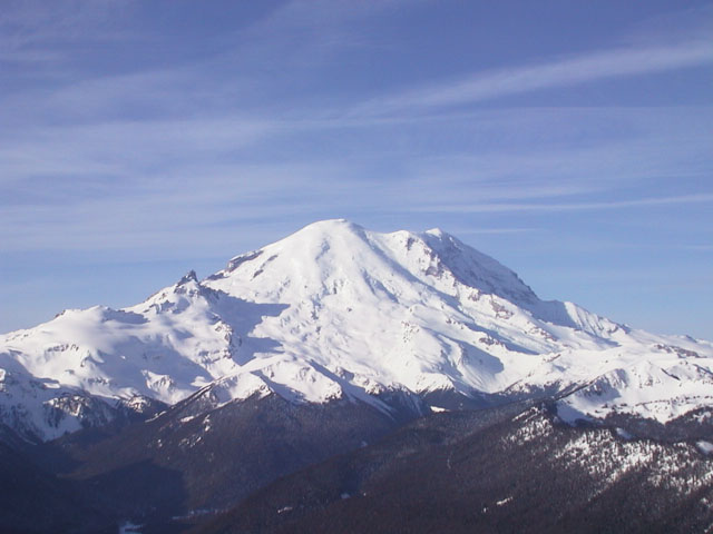
Mount Rainier is the highest volcano and the most heavily glaciated peak in the contiguous United States. It has
been the focus of mountaineering and ski mountaineering activities in the Northwest for much of this century, and
is a popular training ground for those planning future Alaskan or Himalayan expeditions. The massive snowfall
(averaging nearly 700 inches annually, with a record of 1122 inches) builds a deep and stable snowpack which allows
skiing nearly year-round on many areas of the mountain. Although about 5000 people successfully climb Rainier each
year, only a few percent of them ski from the summit. The first ski descent of Rainier did not occur until 1948,
long after other volcanoes such as Adams and Baker. Many would-be summit skiers are deterred by the crevasse
hazard, highly variable ski conditions (often frozen on the summit, with mush down below), and extra effort needed
to haul skis above 14000 ft. However, in favorable conditions, the descents from the summit of Rainier via the
Emmons, DC, or Fuhrer Finger routes are reasonably safe and extremely enjoyable ski runs. The skiable vertical of
well over 10000 feet (3000 m) is the largest in the lower 48 states.
| Route |
Ratings |
Starting
Elevation |
Elevation
Gain |
Roundtrip
Distance |
Notes |
| Quality |
Effort |
Ascent |
Descent |
| Summit Ski Mountaineering Routes:
|
Emmons Glacier /
Winthrop Glacier |
 |

14.0 |
 |
|
4300 ft
(1300 m) |
10100 ft
(3100 m) |
16 miles
(26 km) |
A classic glacier route, with a more remote feel than the standard DC route.
When filled in by heavy snowfall in late spring, this route is surprisingly safe,
with minimal hazard from the many deeply-buried crevasses. Superb skiing in the
large bowl from 11000-13000 ft, where recent glacial conditions have produced a consistent
30-35 degree pitch (somewhat steeper than the guidebooks say). The bergschrund near 13500 ft
may be tricky to cross, and depending on current conditions it may be safer to traverse this
area on foot even on the descent. On the way back to the car,
the trail below Glacier Basin (5900 ft) is often unskiable after early spring.
(See my
ski trip report from July 1999 for more details.) |
Disappointment
Cleaver (DC) /
Ingraham Glacier |
 |
13.0 |
|
|
5400 ft
(1650 m) |
9000 ft
(2700 m) |
16 miles
(26 km) |
The standard guided summit route, often very crowded unless you know the secrets
of avoiding the hordes (see my
climbing trip report from July 1999 for some hints). Skiable through Cadaver Gap
to Ingraham Direct in early season. Later in year will require hiking the talus slope through
Cathedral Gap, followed by a difficult crossing of the broken-up Ingraham Glacier.
The north edge of the glacier (beside the Cleaver) is usually not too heavily-crevassed
from above the Nose of the Cleaver up to its top at 12400 ft. From there th=o the |
| Gibraltar Chute |
 |

12.5 |
 |
 |
5400 ft
(1650 m) |
9000 ft
(2700 m) |
14 miles
(22 km) |
Shortest and most direct summit route, but exposed to extreme rockfall hazard from Gibraltar
Rock and icefall hazard from the overhanging Nisqually Ice Cliff. Slopes to 50 degreees.
(There is a snowboard descent photo on lead climbing ranger
Mike Gauthier's website.) |
| Fuhrer Finger |
 |
12.5 |
 |
|
5400 ft
(1650 m) |
9200 ft
(2800 m) |
14 miles
(22 km) |
Shortest and fastest of the safer summit routes. Avalanche and rockfall hazard in 45-degree
main chute in warm spring conditions. Continuous ski descent of 10400 vertical
ft (3200 m) is possible from summit to Nisqually Bridge (first done in 1980). |
Tahoma Glacier
(direct approach) |
 |

18.5 |
|
|
5400 ft
(1650 m) |
12200 ft
(3700 m) |
25 miles
(40 km) |
A very long route, with several possible routes to high camp at 9200 ft. The best
option is to ski directly up Tahoma Creek from the road closure (avoiding many miles of
hiking the road), possible only in early season with heavy snowfall. Since the Tahoma
Glacier is very heavily crevassed, a deep snowpack is necessary in order to
make a ski descent from the summit feasible at all. |
Mowich Face
(Edmunds Headwall) |
|
15.5 |
|
|
5400 ft
(1650 m) |
10500 ft
(3200 m) |
20 miles
(32 km) |
Extreme route, slopes to 50+ degreees. First ski descent in July 1996.
Not nearly as exposed as Liberty Ridge, except at the top of the face.
Skiable only with a deep snowpack which is not too windblown or icy for
safe skiing. |
Liberty Ridge
from White River |
|
15.5 |
|
|
4300 ft
(1400 m) |
11000 ft
(3400 m) |
18 miles
(29 km) |
Extreme route, slopes over 50 degreees. First ski descent in 1980, and rarely repeated.
Extremely exposed, with several thousand foot drop onto Carbon Glacier possible.
One skier in party of three fell 2000 ft to his death, May 1999. |
| Other Ski Mountaineering Routes:
|
| Muir Snowfield |
|

7.0 |
 |
 |
5400 ft
(1650 m) |
4700 ft
(1400 m) |
9 miles
(15 km) |
The classic day trip on Rainier, a fine choice in any season and a
superb introduction to ski mountaineering for skiers ready to finally leave the
lifts behind. Skiable year-round between 7000-10000 ft.
Often crowded, but safety in numbers and easy access to emergency
help makes this a good solo trip when one's companions stay at home. (See my
ski trip report from June 1997.) |
| Paradise Glacier |
|
7.5 |
|
 |
5400 ft
(1650 m) |
4700 ft
(1400 m) |
11 miles
(18 km) |
Much less crowded than Muir Snowfield, this route is usually nearly crevasse-free in spring,
and not too dangerous in early summer, although there are usually a few crevasses open.
It joins the Muir Snowfield at 9000 ft, so one can ascend Muir and then descend this route. |
Nisqually Glacier
(lower portion) |
|
7.0 |
|
|
5400 ft
(1650 m) |
4700 ft
(1400 m) |
11 miles
(18 km) |
Ski or climb up to Camp Muir from Paradise, then descend chutes to Nisqually Glacier and ski for
6200 vertical ft (1900 m) to Nisqually Bridge. Lower sections can become treacherous
in spring as the snowpack thins due to swift river flowing underneath. Car shuttle
back to Paradise, or simply park at the bridge and hitch a ride in the morning. |
Van Trump Park
to Camp Hazard |
|
9.0 |
|
|
5400 ft
(1650 m) |
6000 ft
(1800 m) |
11 miles
(18 km) |
A fine alternative to Muir, with much steeper and more interesting ski terrain.
As with previous route, can ski out to Nisqually Bridge before mid-spring in order
to get a much longer run. |
Circumnavigation
near 10000 ft level |
|
24.5 |
|
|
5400 ft
(1650 m) |
18000 ft
(5500 m) |
26 miles
(42 km) |
A grand 4-6 day tour, starting/ending from either Paradise or White River, and traversing
around Rainier between 7000 and 11000 ft. Many opportunities for fine
skiing during the many descents and ascents required to cross the
various glacial troughs. See the new
map and guide for more much information.
|
Flett Glacier /
Russell Glacier |
|
9.0 |
|
|
4900 ft
(1500 m) |
5200 ft
(1600 m) |
15 miles
(24 km) |
A fine route, without much crevasse danger on the relatively inactive glaciers.
Best done in late spring and summer, when there is road access to Mowich Lake
and fine corn snow. Earlier trips require many miles of skiing, snowmobiling,
or hiking up the snowbound (or melted out, but closed) road. |
Carbon Glacier
from Ipsut Creek |
|
11.0 |
|
|
2300 ft
(700 m) |
6500+ ft
(2000+ m) |
18+ miles
(30+ km) |
A long trip starting from very low elevation, requiring a long hike most of the year.
Can ski up nearly to base of Willis Wall at 9600 ft, although the upper end is exposed
to huge ice avalanches falling from the summit dome 4000 ft above.
Unsuitable after late spring due to meltout/breakup of the active Carbon Glacier. |
Interglacier
to Steamboat Prow |
|
8.0 |
|
|
4300 ft
(1400 m) |
5400 ft
(1600 m) |
10 miles
(16 km) |
The lower portion of the Emmons climbing route, makes a superb day trip by itself
up to Steamboat Prow. Stunning views of the Emmons Glacier from the Prow, and a
consistent, moderately-steep pitch descends for 3500 vertical ft below it, often with
perfect corn snow after late spring.
The glacier is crevassed, but usually quite safe until midsummer. |
Summerland /
Fryingpan Glacier |
|
9.5 |
|
|
3900 ft
(1200 m) |
5400 ft
(1600 m) |
16 miles
(26 km) |
This eastside route ascends Fryingpan Creek to one of the nicest
sections of the Wonderland Trail which encircles Rainier. Multiple ski options
heading south to Panhandle Gap, or SW below Meany Crest and then W up
onto the Fryingpan Glacier. Minimal crevasse hazard before midsummer. |
Little Tahoma
(11138 ft / 3395 m)
via Fryingpan and
Whitman Glaciers |
|
12.0 |
|
|
3900 ft
(1200 m) |
7200 ft
(2200 m) |
20 miles
(32 km) |
An extension of the previous route. In good conditions, Little Tahoma, the
prominent satellite peak east of Rainier, is skiable from up to 10800 ft (3300 m)
in the east side gully. Above the snow, the route to the summit involves loose
and exposed rock scrambling, and a hand-line or other protection would be helpful
especially when climbing in ski boots. From the summit there is an unusual and stunning
close-up view of the east side of Rainier, including the Emmons and DC routes. |
|
Upcoming additions: |
Topographic map showing all ski routes. |
Full page descriptions and photos of Emmons, Muir, DC, Fuhrer Finger,
Flett/Russell, and possibly other routes. |

|
Panoramic version of photo at top, digitally composited from two photographs
(photo by Amar Andalkar) <click to enlarge>
|
|

|
Panoramic view of Rainier from the south above Panorama Point,
digitally composited from three photographs;
Muir Snowfield arcs along the right, with Nisqually Glacier and Fuhrer
Finger routes at center and Kautz Cleaver on left skyline
(photo by Amar Andalkar) <click to enlarge>
|
Useful Web Links:
List of Guidebooks: (detailed references on the
bibliography page)
More photos, routes, links, references, etc. coming soon...
Please contact me with any suggestions, additions, or corrections.
|